
Thunderstorms don’t just appear out of thin air, say scientists #
The UK Centre for Ecology & Hydrology published yesterday the article you can read there, or here.
Climate change is bringing more intense rainfall, and improving forecasting and warnings to communities globally will save the lives of people and livestock as well as better protect property and infrastructure. Thunderstorms caused around 30,000 deaths and $500 billion in economic losses between 2010 and 2019, according to the World Meteorological Organization.
The research focused on sub-Saharan Africa where there are regularly intense thunderstorms, and there is an urgent need to improve knowledge and forecasting where flash-flooding has a big impact on large urban populations.
There is no randomized way #
Lead author Professor Christopher Taylor, a meteorologist at UKCEH, said: “Thunderstorms can sometimes suddenly appear, seemingly ‘out of thin air’. But our research has shown that where they are triggered is more predictable than was previously thought."
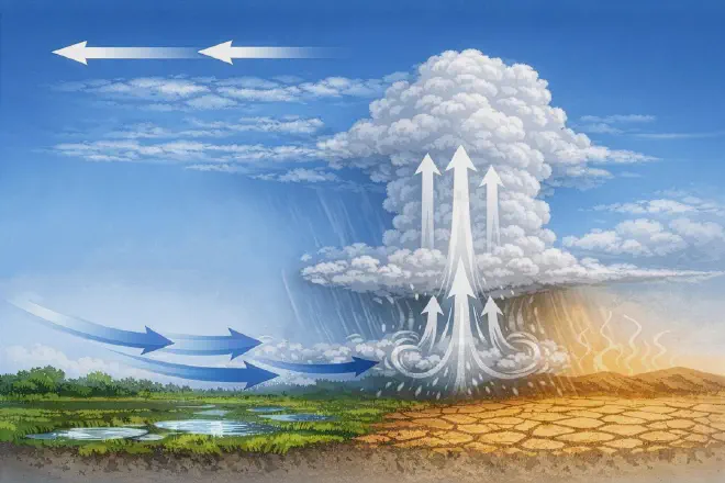
Professor Taylor explained the study brought together ingredients of thunderstorm development that had previously been treated separately. It is well known that how winds vary with height – known as shear – affects storm severity, and also that high temperatures from parched soils located close to cooler, wetter ground favours the growth of storm clouds.
Guiding improvements #
The research, funded by the Natural Environment Research Council and the Met Office, both from UK, found there were 68% more explosive storms given favourable soil moisture patterns. The study was made possible by an innovation by TU Wien that enabled scientists to obtain high-resolution data from satellite images, in order to reveal finer-scale details of soil wetness every day.
Dr Cheikh Abdoulahat Diop of ANACIM, the national meteorological agency in Senegal, said: “This latest study can guide improvements to early warning systems for flash flooding, lightning hazards and severe wind, which will be especially beneficial for affected regions that have high populations but limited weather radar coverage.
“Ongoing research by UKCEH and partners is improving scientific understanding of land-atmosphere interactions, and is already delivering major benefits for forecasting and risk planning across West Africa.”, he added
This has included the development of ‘nowcasting’ tools that provide warnings of storms up to six hours ahead.
Article from TU Wien #
Thunderstorms are known to form preferentially on warm, humid days with unstable air, stated an article from Technische Universität Wien. But predicting where exactly a thunderstorm will develop has so far remained extremely difficult. Heavy rainfall often occurs very suddenly and locally – without warning, yet frequently with severe consequences.
Soil moisture as a driver of thunderstorms #
“Large-scale air-mass movements can be calculated very well today,” says Prof. Wolfgang Wagner from the Department of Geodesy and Geoinformation at TU Wien. “But thunderstorms form on intermediate spatial scales – on the order of a few kilometres. And this is precisely where current models reach their limits”, he said
For many years, TU Wien has been developing methods to derive soil-moisture information from satellite measurements on a global scale. Improvements in the spatial and temporal resolution of these satellite data have now made it possible to directly relate thunderstorm observations to soil-moisture patterns. This revealed a striking relationship:
- Thunderstorm cells tend to grow particularly rapidly and intensely where differences in soil moisture generate near-surface winds, while winds at higher altitudes blow in the opposite direction.
If the soil in one region is wetter than in its surroundings, evaporation cools the near-surface air. Over drier areas, the air warms more strongly and surface pressure is lower. As a result, near-surface air flows from wetter towards drier regions. Wind directions several kilometres above the ground, however, are largely determined by large-scale weather systems and are mostly independent of local soil moisture.
Under these conditions, convection is strongest: moist air is drawn upward from below, cools as it rises, and can rapidly form large thunderstorm clouds. A self-reinforcing upward motion develops – a local instability turns into a thunderstorm. This sensitivity to small-scale conditions is precisely what makes thunderstorms so difficult to predict.
Millions of thunderstorms confirm the model #
High-resolution satellite measurements of soil moisture were crucial for this analysis. These data were developed at TU Wien and provided by EUMETSAT, the European Organisation for the Exploitation of Meteorological Satellites. The study uses data from the European ASCAT instrument, which orbits the Earth aboard the Metop satellites operated by EUMETSAT. Using sophisticated, tailor-made physically based models, these measurements allow detailed estimates of local soil-moisture conditions.
Citation #
- The paper Wind shear enhances soil moisture influence on rapid thunderstorm growth was published in Nature journal. Authors: Christopher M. Taylor, Cornelia Klein, Emma J. Barton, Sebastian Hahn & Wolfgang Wagner
Taylor, C.M., Klein, C., Barton, E.J. et al. Wind shear enhances soil moisture influence on rapid thunderstorm growth. Nature 651, 116–121 (2026). https://doi.org/10.1038/s41586-025-10045-7
-
The article Thunderstorms don’t just appear out of thin air, say scientists was published in the UKCEH press website
-
You can read here Dangerous thunderstorms: better models through soil-moisture data the article from TU Wien
Contact [Notaspampeanas](mailto: notaspampeanas@gmail.com)